 |
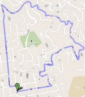
| Route suggested by MapMyRun |
This is the route that was suggested to me on MapMyRUN. It tallies in at 3 miles, and shows an ascent of over 400 feet. I have been trying to build endurance, so I was excited to run some hills. However, this path was not very obvious when you were actually on it (it was hard to tell where to turn, and there were a lot of paths between streets). As you can imagine, I got lost. There was no more sidewalks, and the hills became extremely steep. I also didn't remember seeing Glendale Ave on the map before I left (and sure enough it is not even on this map).
This was one of the very few occasions that I did not have my blackberry on me, and one of the occasions where it would have been useful. I decided to turn left instead of turning around, since I knew heading in that direction would probably lead me to a road name I would recognize. Sure enough, after about 5 minutes of running I encountered a street I recognized, and decided to improvise the rest of the way home, which actually turned out to be really somewhat to the suggested running path.
 |
| The route I actually took. |
As you can see, I stayed on one street by mistake, which sent me east instead of north. I still enjoyed my run, and it clocked in at 3.6 miles instead of 3 miles (not necessarily a bad thing). If any lessons can be gained from this, it is to either remember the route (or print off the map) if you are unsure of the area, or bring your phone with you when you run.
I will definitely use MapMyRUN again, though I think next time I will choose a route in an area that I am more familiar with (and less hilly).
On another note, I noticed that Lululemon has come out with a Mind over Matter jacket. I already see a huge problem with this jacket:
This jacket offers virtually no protection from the elements! You'd get soaked if it started raining during your run. I heard this is priced at $128, which is outrageous in my opinion! I think I have to go to a Lululemon store and try this on for myself to see what the deal is. I'll be sure to post pictures when I do.
In any case, I'll stick to wearing my lilac snow pacesetter pullover when I go for a run.


No comments:
Post a Comment